
Upper Arlington Street Directory Route
An Upper Arlington street directory search works best as a documented property trail. The Franklin County Auditor accepts a street address, while the Recorder does not use street address as an index value. Start with the address, then keep the parcel number, situs address, legal description or subdivision clue, and transfer detail together. Those are the bridge to a recorded instrument. The sequence can identify a property record, a recorded transfer, a map position, or a dated historic listing. It cannot establish a complete list of people at a home.
- Open Franklin County Auditor Property Search in Address mode and locate the street number.
- Record the parcel ID, situs address, legal description or subdivision wording, and transfer or sales clues shown in the property result.
- Search Recorder Cloud Search with the parcel, legal-description, subdivision, or party clue. Do not submit the street name as though it were a Recorder index.
- Use the Parcel Viewer to orient the parcel on the street and move to the correct property detail.
- For municipal work or an older occupant clue, use the City permit/request channels or Columbus Metropolitan Library street and telephone materials for the relevant date.
Keep the result URL or counter contact beside each clue. A parcel number is stable land-system evidence, while a directory entry is a dated listing and a permit file is municipal context.
Upper Arlington Address Search Fields
The Auditor Property Search is the address-facing part of the Upper Arlington street directory. Choose Address mode rather than trying to force a full mailing line into an owner search. The interface separates the numbered address from direction, name, unit, and suffix conventions. Search as the form asks, then open the actual parcel detail before deciding what an address label represents. The site describes property details, appraised value, sales history, tax information, maps, and other records. Those are property-record fields, not a count of people at the address.
| Field | How the Auditor describes it |
|---|---|
| Street No. | Use the street number in Address mode. |
| Direction | Leave blank or select E, N, NE, NW, S, SW, or W. |
| Street Name | Enter the name without a suffix. |
| Unit | Use the unit field when the address has one. |
| Wildcard | An asterisk * is supported. |
| Owner | Use Last Name First Name or part of it; do not use single or double quotes. Up to 500 results may return when an exact match is absent. |
Owner mode can sort results by parcel ID, address, Owner 1, or Owner 2. It is useful after an address result supplies a name, but an owner name should be checked against the parcel and date before it is connected to a street address.
Upper Arlington Parcel Clues
A parcel is the county’s land-record identifier for a defined piece of property. The situs address is the physical location used for property and map research. A mailing address, when shown in a property record, is where tax correspondence goes and can differ from the situs. The legal description identifies land through a lot, subdivision, condominium, parcel, or other recorded wording. Copy those values exactly before moving from an Upper Arlington street search into the Recorder system.
- Parcel
- A county identifier that anchors one property record and helps link the Auditor, GIS, Treasurer, and Recorder pathways.
- Situs address
- The physical location of the parcel, not necessarily the address for mailed tax correspondence.
- Legal description
- Recorded land wording, such as lot or subdivision language, used to distinguish a property in land records.
- Plat
- A recorded subdivision drawing that can show lots, streets, alleys, building lines, and dimensions, but not building plans.
Note: Compare a mailing label and a situs label in the live parcel detail before treating either one as evidence about occupancy.
Upper Arlington Recorder Street Gap
The key local quirk is simple but important: the Recorder does not index a street address, and the Auditor does. A useful Upper Arlington street directory chain is address to parcel or legal description to recorded instrument. That is why a Recorder street-name search can fail even when the property has a recorded deed. The Recorder’s own FAQ directs address searchers to the Auditor for a parcel number, then back to Recorder documents.
| Cloud Search control | Use in a street-record trail |
|---|---|
| Grantor/grantee, subdivision, doc type, or doc# | Enter the party, subdivision, document type, document number, or parcel-related clue obtained from the property trail. |
| Starting and ending recorded dates | Narrow the recorded-date range when a transfer period is known. |
| Recorded Date | Select the observed date-basis control when setting the range. |
| Standard or OCR | Use standard search or OCR text search, then verify any hit in the instrument and legal description. |
Cloud Search accepts basic public searching without registration. An OCR phrase hit is only a lead. Confirm the party names, recording date, instrument number, and legal description before treating a result as connected to the parcel.
Upper Arlington Street Map Context
The Parcel Viewer serves a different role from the property roll and Recorder index. Use By Shape to draw an area, By Value to choose a layer and field, or By Spatial to find a parcel, enter a distance, select Apply Buffer, and choose parcels wholly within or intersecting that buffer. Documented value choices include parcel ID, subdivision or condominium name, annexations, and special tax districts.
The Results tab can export selected results to CSV. The Identify tool selects a mapped feature and links to its Property Search detail. This creates a careful street-by-street workflow: use the map to orient a known parcel or examine boundaries, then open property detail one parcel at a time. It does not turn nearby parcels into a roster of people.
Upper Arlington Street Tool Comparison
Upper Arlington street research has several tools, but each has a separate job. Auditor Address Search identifies the current property record and its parcel clues. Recorder Cloud Search follows recorded instruments and parties. Parcel Viewer explains location, adjacent geography, and map layers. CML directories place a listed occupant or subscriber at an address in a particular year. City requests supply municipal-file context when a permit portal does not expose the needed record.
Using the wrong tool creates predictable errors. An Auditor result is not a full household list, a Recorder result is not street-indexed, a map selection is not a social relationship, and a directory entry is not a deed. Keep the sources separate, then compare their dates and identifiers.
Upper Arlington Street Records
Each Upper Arlington street record answers a narrower question. The property roll and Treasurer search are address-friendly. The Recorder preserves recorded instruments but relies on parcel, legal-description, subdivision, document, or party clues. The map adds spatial context. City and library sources fill different, limited gaps.
| Record Set | Keeper | What It Shows | Access |
|---|---|---|---|
| Property roll | Franklin County Auditor | Parcel identity, owner labels, value, sales, taxes, maps, and other property records | Address, owner, parcel, subdivision, map, and intersection modes; not a household roll |
| Tax property search | Franklin County Treasurer | Tax-side property lookup by name, street address, or parcel ID | Public search; portal carries a no-warranty notice |
| Recorded instruments | Franklin County Recorder | Deeds, mortgages, releases, liens, assignments, plats, leases, and partnerships | Parcel, legal-description, subdivision, party, or document search; no street-address index |
| Parcel map | Auditor GIS | Parcel location, layers, spatial selection, and link to property detail | Public viewer; map proximity is not a household relationship |
| City permits and maintenance | Upper Arlington Community Development | Municipal work or maintenance context when available | Portal fields were not verified; use a City request or phone fallback |
| CML directories | Columbus Metropolitan Library | Dated listed occupants or subscribers at an address | Street section begins in 1911; coverage and inclusion vary, and a listing is not ownership |
The parcel ID and legal description connect the county tools. A street label alone does not. For a current property question, compare Auditor and Treasurer results, then inspect the recorded document. For an historic address, read the library record as an annual clue rather than an ownership finding.
Upper Arlington Tax-Side Address Check
The Treasurer offers a compact second property channel after an Auditor result. Its public search accepts a name, street address, or parcel ID, with examples such as a person name, a numbered street, or a parcel identifier. Use the exact property trail already developed, not a broad street sweep. The Treasurer’s accuracy and no-warranty notice is a reason to compare the live tax-side result against the Auditor property detail and the recorded instrument.
See the Franklin County Treasurer property-search screen before running that confirmation.
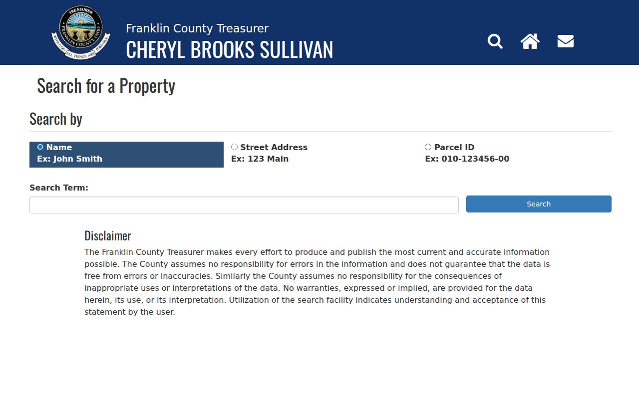
The Treasurer screen shows the separate name, street-address, and parcel-ID starting choices that make it a useful tax-side check, not a substitute for the Recorder’s instrument search.
Upper Arlington Deeds by Street
Once an Upper Arlington street address has become a parcel and legal-description trail, recorded deeds can supply the instrument chronology. A grantor is the party conveying an interest; a grantee is the party receiving it. Start with the most recent transfer clue, record the instrument number or book and page, then test the next earlier document against the same legal description and parcel continuity. A shared surname is weak evidence without those supporting details.
Recorded documents can include deeds, mortgages, releases, liens, assignments, plats, leases, and partnerships. A Recorder employee can help explain the public search tools in person, by phone, or by email, but cannot conduct a title search or give legal advice. Certified-copy requests are available online, by mail, or in person when an official copy is needed.
Upper Arlington Street Directory Clues
For a past address, Columbus Metropolitan Library offers a bounded street-directory layer. Its city directories are annual from 1841, and the street-address section begins in 1911. That section can place a listed occupant at an address for a publication year, but it does not establish deed ownership or continuous residence. Search the exact old spelling and number, then compare nearby years before drawing a conclusion.
The Library’s digitized 1926 telephone directory is arranged by street name and lists subscribed households and businesses. A 1935 Ohio Bell telephone directory explicitly includes Upper Arlington, a stronger local coverage statement than assuming every Columbus volume did. These are historic subscriber and directory clues. For the full collection and staff help, use the CML Local History and Genealogy service; digitization remains in progress.
Upper Arlington Permit Follow-Up
Municipal records are an appropriate next step when the question is about an improvement, property maintenance matter, or a City document rather than ownership. The City Quick Links identify a permit and registration portal, public documents, property search, GIS mapping, and request channels. The captured permit interface did not expose verified searchable fields, so it would be inaccurate to promise a particular address-field result.
Use the City Quick Links, call the Permit Portal at 614-583-5070 or Property Maintenance at 614-583-5073, or make a focused City records request. For historic municipal material, name the address, time span, and record type. City files provide municipal context; they do not prove a county ownership chain by themselves.
Note: A temporary slow or limited Auditor result during the 2026 system upgrade is a reason to retry or use Parcel Viewer, Treasurer, Recorder, or a county counter.
Upper Arlington Street Search Limits
County property and map records do not index all household members. A historic directory can omit a non-subscriber, abbreviate a given name, or fall outside the address’s coverage. The state voter web tool is a name-and-county check, not a street roster. Utility and delivery customer lists are not public residents lists, and protected voter or address information remains outside public display. Safe at Home participants may use a substitute address, so a redaction or absence is not a gap to work around.
Lawful use. Use Upper Arlington street records for lawful personal, family-history, estate, civic, or scam-verification research. Ohio laws including R.C. 2903.211 and R.C. 2917.21 address menacing by stalking and telecommunications harassment.
Note: When a record needs correction, copy certification, or an explanation of an exemption, ask the office that keeps the original record.