
Upper Arlington Previous Resident Sources
Different records answer different parts of a house-history question. The Franklin County Auditor supplies the present parcel doorway. The Recorder supplies recorded instruments and indexed parties. Historic directories and telephone books can identify a dated listed occupant, while maps describe place and period. City permit files can add an improvement lead, but no verified citywide permit coverage period supports a claim that every era is searchable. Preserve the source’s own coverage wording, especially for early land records.
| Source | Years It Covers | Where Held | What It Shows |
|---|---|---|---|
| Recorder archival deed indexes | 1804-1913 | Franklin County Recorder archival / legacy instructions | Grantor and grantee pathway with book and page clues |
| Recorder deed index | Begins January 2, 1914 | Franklin County Recorder search and training materials | Later deed-name and recorded-instrument route |
| Deed books described by CML | Back to 1803 | Franklin County Recorder office | Library guide’s deed-book description, not a claim about every index |
| Columbus city directories | Back to 1841; street section from 1911 | CML Main Library and digitized collection | Annual listed occupants, not proof of owners |
| Auditor Parcel Archive | 1995-present | Franklin County Auditor Online Tools | Parcel map-history lead |
For a modern parcel question, start at the Auditor. For a property that predates the current address, stabilize the legal description and use the Recorder archive path as the later index stops. For households, test a directory listing against an available census, map, obituary, or probate clue instead of treating any one source as a full resident list.
Upper Arlington Address to Instrument
Upper Arlington uses two different record systems for the same property question. The Auditor accepts a street address and returns the practical property record. The Recorder does not index recorded documents by street address. Its own guidance directs a researcher to begin with the Auditor, copy the parcel number or legal-description clue, and then search the Recorder for instruments connected with that land. This address to parcel to instrument sequence is the key local research quirk.
Save the situs address, parcel ID, subdivision or lot wording, legal description, recording date, instrument number, and source location as each result appears. A mailing address, when a live property record has one, tells where tax correspondence is sent. It should not be substituted for the parcel’s situs or treated as proof that someone lives there.
Upper Arlington Deed Index Boundary
The early land-record dates need careful wording. Recorder archival instructions identify a special deed-index route for 1804 through 1913. The same Recorder material says its deed index begins January 2, 1914, and its mortgage index begins January 7, 1970. CML’s house-history guide says Recorder deed books go back to 1803. Those statements refer to different books and index contexts, so they should not be compressed into one invented first-year claim.
When a chain crosses the 1914 line, keep the current instrument details and move into the archival index route, the deed books, or Recorder assistance. The archive instructions report that some records were destroyed in the 1879 fire, although most were reconstructed. A missing early result can therefore be an index, image, or reconstruction issue. Cross-check the book or page lead with tax duplicates, probate, plats, maps, newspapers, and archival sources before treating an absence as proof.
Tracing Upper Arlington Deed Chains
A deed chain follows the land, not merely the name. Begin with the current Auditor result, then use its parcel, transfer, legal-description, and party clues in Recorder research. The most recent deed gives a grantor and grantee. The former grantor can become the next person to search backward, but only after the legal description, parcel clues, lot wording, and instrument sequence support continuity. Common names, trusts, estates, corporations, and joint owners require extra care.
- Search the Auditor by street address and record the current parcel ID, situs, and legal description.
- Use the parcel or party clue to locate the latest Recorder deed or transfer instrument.
- Log the instrument number or book and page, recording date, grantor, grantee, and parcel wording.
- Research the prior grantor as the next earlier ownership lead, checking that the legal description remains continuous.
- Repeat the sequence and cross into the archival deed indexes when the later index boundary is reached.
- Use the Recorder counter or archive help where an index gap, fire-related issue, or ambiguous legal description remains.
- Grantor / grantee
- The grantor transfers an interest in the instrument. The grantee receives that stated interest.
- Chain of title
- The linked sequence of recorded land transfers for the same property, supported by dates and land identifiers.
- Legal description
- The lot, subdivision, parcel, or other land wording that identifies property in land records more reliably than a street address alone.
Upper Arlington Maps and Permit Clues
Maps help date the place while the deed chain dates the ownership record. CML lists Columbus Sanborn map sets for 1887, 1891, 1901, 1921, and 1921-51, plus Caldwell, Baist, Modie & Kilmer, and 1937 plat-book material. Sanborn sheets can show building outlines and material clues, but map coverage must be confirmed for the specific Upper Arlington property. A map that does not include the area cannot settle a building question.
For city improvements or maintenance records, Upper Arlington’s Community Development route offers a Permit Portal and City request channels. The research verifies the route but not a historical coverage period or specific public search fields. Ask for a narrow record series, address or parcel, and date span. CML also warns that Auditor year-built values before 1920 are often guesses, so a displayed date deserves an independent check.
Upper Arlington House History Help
When the online property trail ends, CML’s Local History & Genealogy division at the Main Library, 96 S. Grant Avenue, is the documented house-history fallback. Browsing does not require an appointment. Staff appointments and Ask a Librarian assistance are also available for genealogy, local history, and house-history questions. Bring the parcel ID, legal description, address variants, and the date range already tested. That makes it easier to determine whether an old directory, phone book, map, or newspaper collection reaches the property.
Upper Arlington Public Library provides a second local channel. Its Tremont Research Department / Ohio Room holds Franklin County histories, cemetery material, and city and suburban directories from the 1950s, though volumes can be missing. The Upper Arlington News Index reaches from 1982 through the final April 18, 2012 issue, and local microfilm adds Upper Arlington News, Tri-Village News, Citizen Journal, and Columbus Dispatch runs. Use these as period-specific leads, then preserve the date and source rather than blending them into an undated resident history.
Upper Arlington Before Incorporation
Upper Arlington incorporated on March 20, 1918. For an older property, a present city label may conceal a Perry Township, farm, tract, or legal-description context. The original development was not a simple grid: the Thompson brothers bought 840 acres in 1913, Roxbury Road followed in 1914, and the city’s early streets followed contours and names drawn from English magazines. These details make a historical map and the exact land description more useful than a loose modern street search.
The Upper Arlington Archives 1883 historical map records land in the area before the city’s development.
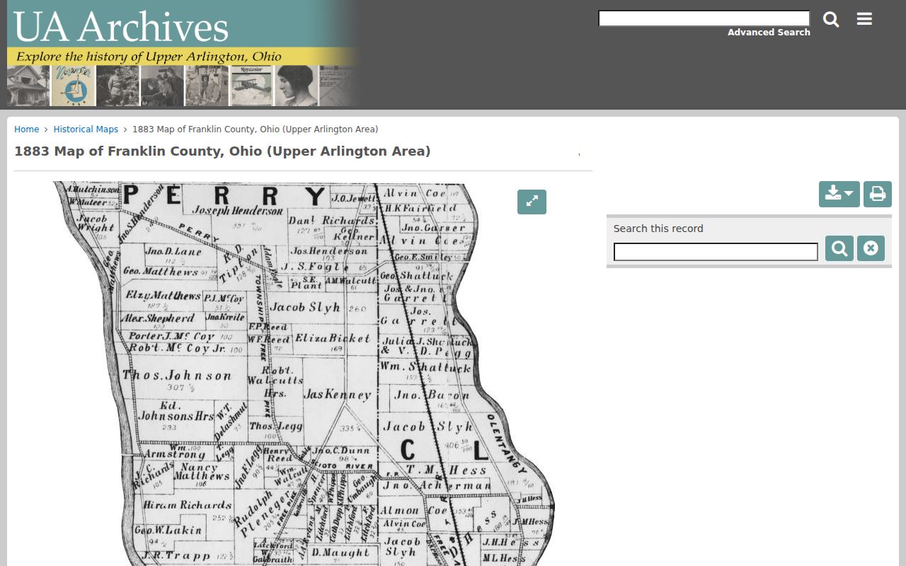
The map supports a continuity check between an early land description and a later city address. It does not supply a resident list. No authoritative citywide street-renumbering or renaming crosswalk was verified, so compare each address with maps, plats, City archives, and its recorded parcel identity.
Upper Arlington Past Household Records
Ownership is only one part of who lived here before. CML’s Columbus directories are annual from 1841, and their street-address section begins in 1911. For a property within the volume’s geographic coverage, check that street section for a listed occupant, then use the alphabetical section to find occupation or other address detail. The 1926 telephone item is another address-arranged lead, but it only represents subscribed households and businesses. The city directory collections explain the volumes and their entry marks in more detail.
Pair each dated listing with an available federal census, but treat the census and directory as separate snapshots. An address may show a listed resident in a directory while a deed identifies a different owner. If a name drops out, check the year before and after, spelling variants and initials, then compare the record against maps, property instruments, obituaries, or a probate file. That process preserves the difference between a resident, a subscriber, a family member, and a recorded land party.
Lawful use. Previous-residents research belongs to house history, family history, and personal curiosity. Do not use records to stalk, harass, or harm a living person; protected address information must remain protected.
Upper Arlington Obituary and Probate Trail
When the evidence suggests a death or estate, use sources that answer that question directly. CML offers obituary requests, up to six free requests monthly, and its local indexes can point toward a source article. Ohio History Connection provides historic death material and archives support. Franklin County Probate Court is the separate custodian for estates, guardianships, marriage licenses, adoptions, and related probate records. An obituary or death-index lead is not a current-location record; it is a dated route to the appropriate historic or probate source.
Close a property timeline by recording where each source agrees and where it does not. A deed might establish a recorded transfer, a directory an occupant, a map a building-era clue, and probate an estate connection. The remaining uncertainty is part of an honest previous-residents history, not a gap to fill with an unsupported name.